A classic Swaledale walk. Initially beckside through a mix of woodland and open country passing Gunnerside Gill’s many mining remains.
Then, after an exciting ascent of a hush, a glorious return, mostly on springy turf, with wide and varied views.
Steps
-
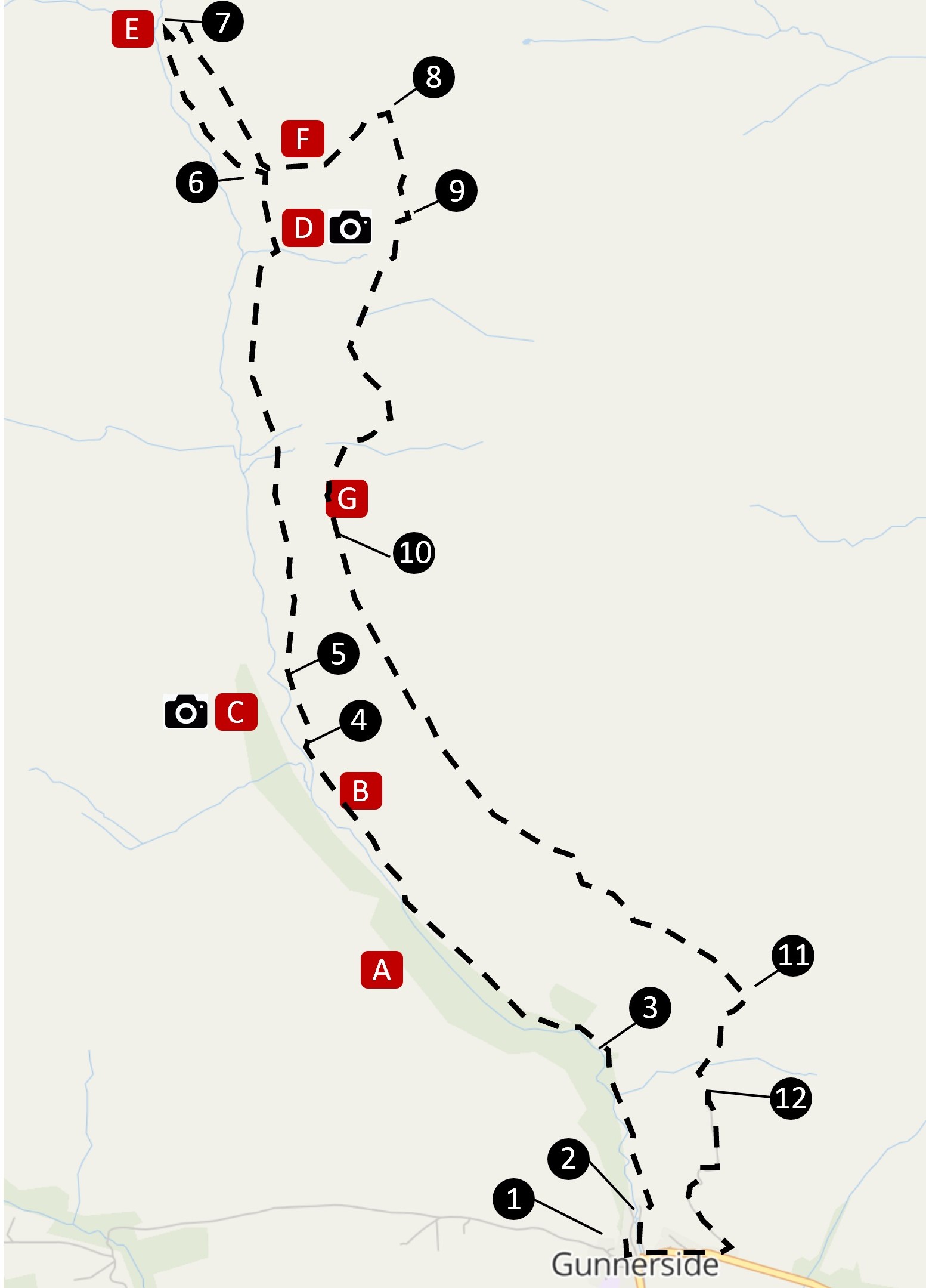
From the car park, turn L over the bridge then immediately L to follow footpath signed ‘Gunnerside Gill’.
-
At gate, take signed path to R up steps. After next gate keep L to continue parallel to beck, soon entering woodland.
-
Emerge from wood and continue with beck on L until a gate leads through a low wall and up steps into woods.
The path rises and falls through the woods, always within earshot of the beck before dropping to a simple footbridge
and emerging to pass through two stiles, one gated. Continue with wall initially to your L, soon arriving at
Sir Frances Dressing Floor.
-
150m on, cross a two-stepped stile, climb slightly then continue above the flood plain until reaching a stone style.
Just before the style is a good place to look across at the Sir Frances Level mining complex. With the right footwear it is
possible (though not always safe) to cross the beck and explore the buildings, some of which have information boards.
-
After the stile, the path leads up through open country rising gently to a large cairn. Soon after, reach the remains
of Bunting mine buildings, sitting above vast spoil heaps. Continue along a stony path, rising to a crossroads
with a 4-way sign and cairn.
-
Walk past cairn and then immediately take clear path on L descending gradually to the beck. Continue to Blakethwaite
Smelting Mill.
-
Beside the long wall of the peat store, a narrow track zigzags up the steep side of the Gill. Take this up to a
level(ish) track, then turn R, returning to the cross roads where turn L on path signed to ‘Surrender Bridge’ leading
steeply up through Friarfold Hush.
-
Emerge over the gravel at the top of the hush into a different world. There is a small cairn here. Turn R and heading
due S pick up a faint track that becomes clearer (if narrow) as it enters heather. Once in the heather, aim for some
square sheepfolds ahead, besides which are two iron posts.
-
Pass between the posts onto a glorious, mostly grassy, footpath that leads gently down to a lime kiln.
-
Turn L onto a delightful bridle path until reaching a gate in front of a farmhouse where turn L. After a second farmhouse
the track drops slightly to cross a (sometimes dry) stream.
-
20m after stream, cut R across heather down towards a wall. Just before wall, bear R to pass through a gate. 20m after gate
turn sharp L and descend along track to a stream, after which climb to a narrow tarmac road.
-
Here turn R to return downhill to Gunnerside.
Points of Interest
-
Gunnerside Gill Wood is a remaining example of the ancient broadleaved woodland that once covered much of
Swaledale as described in the Museum in Tim Laurie’s section on prehistoric landscape.
-
Sir Frances dressing floor contains eleven step sided bouse teams, used to store ore before sorting
and crushing prior to being transported underground for smelting at Old Gang Mill.
-
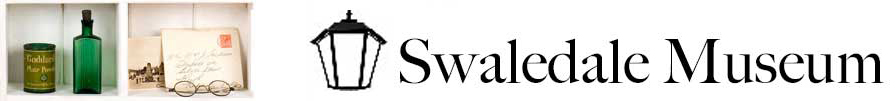
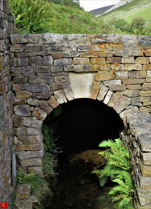
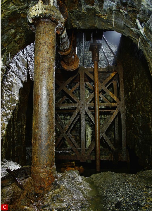
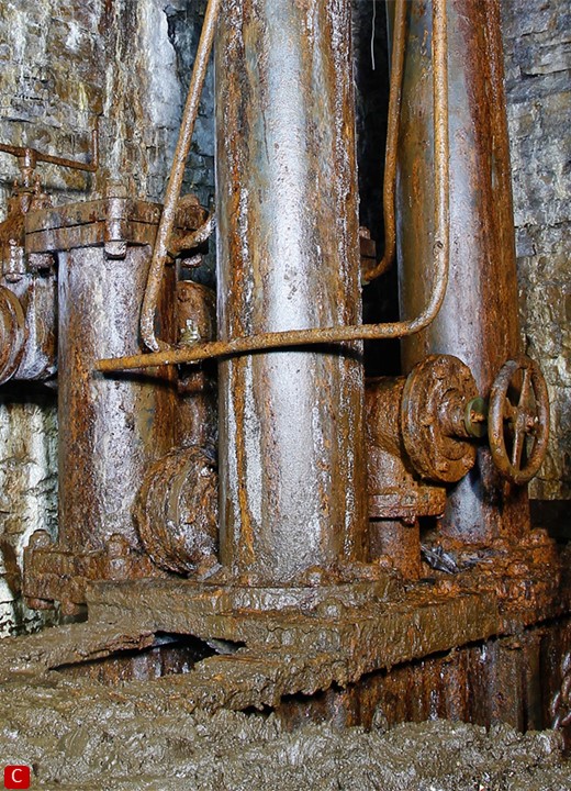
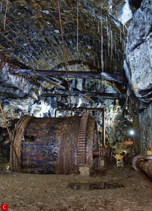
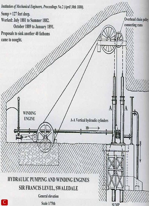
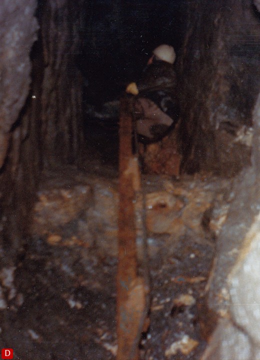
Started in 1864, Sir Frances Level mine was the first in Yorkshire to use compressed air drills. Much
of the machinery is still in tact, the air receiver visible above ground across the beck.
-
Bunting Level connects underground to Old Gang Smelting Mill, two miles east of here. The grassy space
around the buildings is perfect for picnics.
-
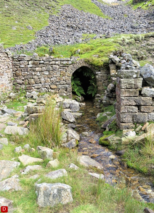
Blakethwaite Smelting Mill, where Blind Gill merges into Gunnerside Gill, with its stone bridge and
lime kiln is another great place to pause.
-
Friarfold Hush is one of three massive hushes (artificial ravines formed by flooding the hillside to
expose lead) on the east side of Gunnerside Gill. Look across to North Hush on the west side.
-
Lime kilns are common in the dales to help sweeten acid soils. They also provided mortar for the
construction of mining buildings.
Mineral surveyor and geologist William ‘Strata’ Smith (1769-1839) has been credited ‘The Father of English Geology’ for creating the first ever detailed geological map at a national scale. His map of 1815, covering much of Great Britain, employed the novel technique of using colours to distinguish various rock strata and set the standards for geological mapping. It looks remarkably similar to modern maps.
It was many years before Smith was recognised for his work and, after a spell in debtor’s prison, he made a living as an itinerant surveyor between 1819 and 1824 before settling near the Yorkshire coast. It was here that his fortunes turned: he was formally recognised by the Geological Society in 1831.
Swaledale Museum contains a hand painted and highly detailed geological cross section of Gunnerside Gill, with colour coded strata according to Smith’s system. Interesting in its own right, this unattributed work dated 1821 illuminates the history of geology and subsequently its influence on the theory of evolution.
There is a crater on Mars, 74km across, named after William Smith.
Credits
All underground photos, David Harper and Paul Steggles (2010) except D2 John Hardy (c 1980). Many more of their photos can be seen in
the museum. Photos have been cropped for presentation. A panel about the life and works of John Hardy is on display in the museum.
Further Reading
Batty, Margaret
, Gunnerside Chapel and Gunnerside Folk 1,2,3
for a flavour of the social history of the area
Clough, Robert
,
The Lead Smelting Mills of the Yorkshire Dales and Northern Pennines their architectural character, construction and place in the
European tradition
, first published 1962 1,3
esp. chapter 5 on Swaledale
Gill, Michael
,
Swaledale its Mines and Smelt Mills
, Landmark Publishing 1993 3
see esp. pp.61-66.
Arguably still the best book on the subject, now out of print.
Hardy, John
,
The Hidden Side of Swaledale
, 1993 1,2,3
Hardy, John
,
Swaledale: Portrait of a North Yorkshire Mining Community
, 1998 3
Hardy, John
,
Occasional papers n the Mines of Swaledale and Arkengarthdale
, 2006 1,2,3
see esp. ‘The Long Race’, p.17.
Plowright, Alan
,
John Henry’s Journeys Two Long Distance Walks in the Yorkshire Dales in 1879
, Moorfield Press, 2009
see esp. pp52-55 for Gunnerside Gill
Raistrick, Arthur
,
The Lead Industry of Wensleydale and Swaledale
, vol.1, The Mines, Moorland Publishing Company, 1975 3
see esp. chapter 5, section on ‘Gunnerside Gill’, pp.48-57.
1: available from Museum bookshop. 2: available via our online shop. 3: available in our Library - contact us to arrange viewing.
|