SWAAG: SWALEDALE & ARKENGARTHDALE ARCHAEOLOGY GROUP
http://www.swaag.org/
SWAAG was launched in 2009 by a group of enthusiasts wishing to contribute to the knowledge base of the history of our two dales of Swaledale and Arkengarthdale. We attempt to link the historic landscape with the human history of the two dales in a way which is academically rigorous, informative and instructive for everyone with an interest in the area.
SWAAG is a Charitable Incorporated Organisation (CIO), registered with the Charity Commission (no 1155775) managed by a board of 9 volunteer trustees. All of SWAAG’s activities are organised and managed by SWAAG volunteers, although for specific areas such a excavations we do engage professional supervisors.
SWAAG is associated with the Friends of the Swaledale Museum. Our Honorary President and guru is Tim Laurie, Co-Director of the Swaledale Ancient Land Boundaries Project 1984-1993 and the leading expert on prehistoric landscapes in the area. Tim has many surveys, excavations and publications to his credit several of which are available on the SWAAG web site.
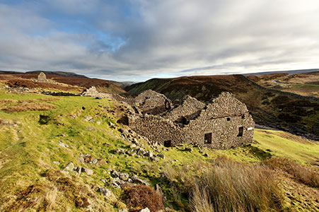
Our wide ranging work programme provides something to interest everyone: walks; seminars; desk-top research on documents, Google Earth and aerial photographs; surveying, mapping and drawing (with an emphasis on the use of GPS, Geophysics and I.T.); photography and sketching; geology, geomorphology and historic land use; recording ancient trees and hedgerows; field-walking; archaeological excavation; recording and analysis of finds; and producing published reports.
We also have formed excellent relationships with the two local schools and volunteers from SWAAG manage outreach activities of curriculum enrichment though which we aim to encourage their interest in archaeology and the local historic environment.
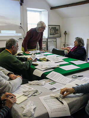
We have a Local History Group which meets in Reeth to discuss members’ research work and other areas of interest. The Group also works in co-operation with the North Yorkshire County Record Office and has transcribed and digitised the 1844 Tithe Apportionment Records for Grinton and Reeth and the the Healaugh and Muker Manor Court records; both are searchable on our website.
Our comprehensive website at www.swaag.org includes details of all of our activities, a comprehensive data base of significant features across the northern dales, an archive of the SWAAG newsletters, and an archive of the field research reports which are free to download. You can also follow us via our Twitter feed @archaeology_s
SWAAG welcomes new members. Please contact us at info@swaag.org, or complete and return the Membership Form on the website.
David Brooks, Chairman SWAAG June 2018